VILLAHARTA Albergue
ESPAÑOL
Nos encontramos en la Casa del Peregrino de Villaharta. Nuestro municipio está situado en un enclave privilegiado del corazón de Sierra Morena. Esta localidad es conocida por sus famosas fuentes de Agua Agria: San Rafael, Fuente Agria, La Lastrilla, La Lastra… En torno a ellas, existieron balnearios donde las personas recibían tratamientos para mejorar su salud. Destacaron el desaparecido balneario de Santa Elisa, de gran fama nacional y que fue visitado por personas de la alta sociedad de la época; y el balneario de Fuente Agria, que llegó a comercializar las aguas por territorio nacional e internacional, logrando importantespremios y reconocimientos por sus propiedades. El Ayuntamiento ha restaurado las fuentes de Malos Pasos y El Cordel, y por iniciativa empresarial local, se ha rehabilitado y puesto en funcionamiento el balneario: “Aguas de Villaharta”. Por estos lugares ha transcurrido tu camino hasta llegar aquí. En 2021, las aguas han vuelto a ser reconocidas oficialmente como aguas mineromedicinales, siendo motivo de orgullo para los lugareños y una atracción para el visitante.
La siguiente etapa será Villaharta – Alcaracejos, con una distancia de 35 km aproximadamente. Es importante llevar provisiones y agua, ya que entre los dos municipios no existen poblaciones intermedias. Nuestro camino transcurrirá por la Cañada Real Soriana GR40, que coincide en un primer tramo con la Carretera de Pozoblanco. Tras pasar el arroyo de las Serranas tomaremos a nuestra izquierda un cómodo carril, que en continuo descenso nos llevará hasta el Río Guadalbarbo (en época lluviosa habrá que cruzar descalzado con precaución). Ascenderemos por nuestro sendero por un bosque típico mediterráneo hasta llegar a una ancha pista que tomaremos a la izquierda. Más adelante, tras pasar por el arroyo del Lorito, volveremos a desviarnos a nuestra derecha donde subiremos hasta el Puerto del Calatraveño, abandonaremos Sierra Morena y nos adentramos en el Valle de los Pedroches. ¡Te deseamos buen camino!
INGLÉS
We are located in the Casa del Peregrino in Villaharta. Our municipality is located in a privileged enclave in the heart of Sierra Morena. This town is known for its famous Agua Agria springs: San Rafael, Fuente Agria, La Lastrilla, La Lastra…. Around them, there were spas, where people received treatments to improve their health. The most well-known were the Santa Elisa spa, which no longer exists, which was of great national fame and was visited by the high society of the time, and the Fuente Agria spa, which marketed its waters nationally and internationally, winning important awards and recognition for its properties. The Town Council has restored the fountains of Malos Pasos and El Cordel, and through a local business initiative, the spa «Aguas de Villaharta» has been restored and put into operation. These are the places through which you have travelled to get here. In 2021, the waters have once again been officially recognised as mineral-medicinal waters, a source of pride for the locals and an attraction for visitors.
The next stage is Villaharta – Alcaracejos, a distance of approximately 35 km. It is important to bring supplies and water, as there are no intermediate towns between the two municipalities. Our route will follow the Cañada Real Soriana GR40, which coincides with the street of Pozoblanco. After passing the Serranas stream we will take a comfortable track on our left, which will take us downhill to the Guadalbarbo River (in the rainy season we will have to cross barefoot with caution). We will ascend along our path through a typical Mediterranean forest until we reach a wide track that we will take to the left. Further on, after passing the Lorito stream, we turn right again and climb up to the Puerto del Calatraveño, leaving the Sierra Morena and entering the Pedroches Valley. We wish you a good journey!
ITALIANO
Ci troviamo nella Casa del Pellegrino a Villaharta. Il nostro comune si trova in un’enclave privilegiata nel cuore della Sierra Morena. Questa città è conosciuta per le sue famose sorgenti di Agua Agria: San Rafael, Fuente Agria, La Lastrilla, La Lastra…. Una volta nei loro dintorni c’erano delle terme, dove la gente riceveva trattamenti per migliorare la propria salute. Le più famose erano le terme di Santa Elisa, che non esistono più, che erano di grande fama nazionale e venivano visitate dall’alta società dell’epoca, e le terme di Fuente Agria, che commercializzavano le loro acque a livello nazionale e internazionale, ottenendo importanti premi e riconoscimenti per le loro proprietà. Il Comune ha restaurato le fontane di Malos Pasos e El Cordel, e attraverso un’iniziativa imprenditoriale locale è stato restaurato e messo in funzione lo stabilimento termale «Aguas de Villaharta». Questi sono i luoghi attraverso i quali hai viaggiato per arrivare qui. Nel 2021, le acque sono state nuovamente riconosciute ufficialmente come acque minerali-medicinali, un motivo di orgoglio per la gente del posto e un’attrazione per i visitatori.
La prossima tappa è Villaharta – Alcaracejos, una distanza di circa 35 km. È importante portare provviste e acqua, poiché non ci sono città intermedie tra i due comuni. Il nostro percorso seguirà la Cañada Real Soriana GR40, che in un primo tratto coincide con la strada di Pozoblanco. Dopo aver superato il ruscello Serranas prenderemo una comoda strada sulla nostra sinistra, che ci porterà in discesa fino al fiume Guadalbarbo (nelle stagioni piovose dovremo attraversare a piedi nudi con cautela). Saliremo lungo il nostro sentiero attraverso un tipico bosco mediterraneo fino a raggiungere un ampio sentiero che prenderemo a sinistra. Più avanti, dopo aver superato il torrente Lorito, giriamo di nuovo a destra e saliamo fino al Puerto del Calatraveño, lasciando la Sierra Morena ed entrando nella Valle di Pedroches. Vi auguriamo buon cammino!
FRANCÉS
Nous sommes situés dans la Maison du Pelèrin à Villaharta. Notre commune est située dans une enclave privilégiée au cœur de la Sierra Morena. Cette ville est connue pour ses célèbres sources de Agua Agria : San Rafael, Fuente Agria, La Lastrilla, La Lastra….. Autour d’eux, il y avait des stations thermales où les gens recevaient des traitements pour améliorer leur santé. Les plus connues étaient la station thermale de Santa Elisa, qui n’existe plus, et qui a connu une grande renommée nationale et qui a été visitée par la haute société de l’époque, et la station thermale Fuente Agria, qui a commercialisé ses eaux au niveau national et international, remportant d’importants prix et reconnaissances pour ses propriétés. Le conseil municipal a restauré les fontaines de Malos Pasos et d’El Cordel, et grâce à une initiative entrepreneurial locale, la station thermale «Aguas de Villaharta» a été restaurée et mise en service. Ce sont les lieux que vous avez traversés à pied pour arriver ici. En 2021, les eaux ont de nouveau été officiellement reconnues comme des eaux minérales-médicinales, une source de fierté pour les habitants et une attraction pour les visiteurs.
L’étape suivante est Villaharta – Alcaracejos, avec une distance d’environ 35 km. Il est important d’apporter des provisions et de l’eau, car il n’y a pas de villes intermédiaires entre les deux municipalités. Notre itinéraire suivra la Cañada Real Soriana GR40, qui pour un premier bout coïncide avec la rue de Pozoblanco. Après avoir passé le ruisseau Serranas, nous prendrons un chemin confortable sur notre gauche, qui nous mènera en descente jusqu’à la rivière Guadalbarbo (en saison des pluies, nous devrons traverser pieds nus avec prudence). Nous monterons le long de notre chemin à travers une forêt typiquement méditerranéenne jusqu’à ce que nous atteignions une large piste que nous prendrons à gauche. Plus loin, après avoir passé le ruisseau Lorito, nous tournons à nouveau à droite et montons jusqu’au Puerto del Calatraveño, quittant ainsi la Sierra Morena et entrant dans la vallée de Pedroches. Nous vous souhaitons bonne route !
ALEMÁN
Wir befinden uns im Pilgerhaus in Villaharta. Unsere Gemeinde befindet sich in einer privilegierten Enklave im Herzen der Sierra Morena. Diese Stadt ist bekannt für ihre berühmten Quellen von Agua Agria: San Rafael, Fuente Agria, La Lastrilla, La Lastra…. Um sie herum gab es Kurbäder, in denen die Menschen Behandlungen zur Verbesserung ihrer Gesundheit erhielten. Die wichtigsten waren das landesweit bekannte Thermalbad Santa Elisa, das heute nicht mehr existiert und welches von der damaligen High Society besucht wurde, und das Thermalbad Fuente Agria, das sein Wasser national und international vermarktete und für seine Eigenschaften bedeutende Auszeichnungen und Anerkennungen erhielt. Die Stadtverwaltung hat die Brunnen von Malos Pasos und El Cordel restauriert, und durch eine lokale Geschäftsinitiative wurde das Thermalbad «Aguas de Villaharta» restauriert und in Betrieb genommen. Dies sind die Orte, durch die Sie gereist sind, um hierher zu gelangen. Im Jahr 2021 wurde das Wasser erneut offiziell als Heilwasser anerkannt, was die Einheimischen mit Stolz erfüllt und die Besucher anzieht.
Die nächste Etappe ist Villaharta – Alcaracejos, eine Strecke von etwa 35 km. Es ist wichtig, Vorräte und Wasser mitzubringen, da es keine Zwischenstädte zwischen den beiden Gemeinden gibt. Unsere Route folgt der Cañada Real Soriana GR40, die ein Stück lang mit der Carretera de Pozoblanco zusammenfällt. Nachdem wir den Bach Serranas passiert haben, nehmen wir einen bequemen Weg zu unserer Linken, der uns bergab zum Guadalbarbo-Fluss führt (in der Regenzeit müssen wir ihn barfuss und mit Vorsicht überqueren). Wir steigen auf unserem Weg durch einen typischen mediterranen Wald auf, bis wir einen breiten Weg erreichen, den wir nach links nehmen. Nachdem wir den Bach Lorito passiert haben, biegen wir erneut rechts ab und steigen zum Puerto del Calatraveño hinauf, verlassen die Sierra Morena und gelangen ins Pedroches-Tal. Wir wünschen Ihnen eine gute Reise!
FOTOGRAFÍAS:
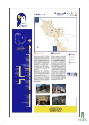
Cruz de granito.
INGL: granite cross
IT: croce di granito
FR: croix de granit
AL: Granitkreuz
Vista aérea.
INGL: aerial view
IT: vista aerea
FR: vue aérienne
AL: Luftaufnahme
Fachada de la Iglesia de Nuestra Señora de la Piedad.
INGL: Façade of the curch of Our Lady of Mercy.
IT: Facciata della chiesa di Nostra Signora della Pietà.
FR: : Façade de l’église de Notre Dame de Compassion.
AL: Fassade der Kirche Unsere Liebe Frau der Frömmigkeit.
Interior de la Iglesia de Nuestra Señora de la Piedad.
INGL: Inside the curch of Our Lady of Mercy.
IT: Interno della chiesa di Nostra Signora della Pietà.
FR: Intérieur de l’église de Notre Dame de Compassion.
AL: Innenraum der Kirche Unsere Liebe Frau der Frömmigkeit.